|
 |
July 1998 |
|
 |
Editrorial
No Shoreplace of Port Hacking is Free of the Impact of People
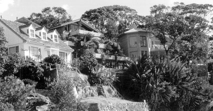
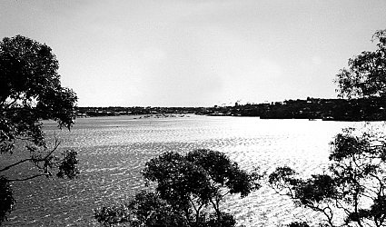
Port Hacking's foreshore is one of its greatest assets. Sitting on a balcony, beach, boat or headland; fishing, swimming, surfing, sailing or canoeing, the foreshore impacts the eye. On the northern shores rise a predominance of tightly clustered houses - some breathtaking in their size and prevalence. On the southern shores trees, bush, mangroves and beaches still dominate, broken only by the picnic grounds at Bonnie Vale and the villages of Maianbar and Bundeena.
No matter where you go in Port Hacking, the human impact is evident. It is, of course, evident in the built environment: houses, boat ramps, marinas, picnic grounds, swimming pools and the like. It is, however, evident in more insidious ways. Ways that are silently destructive of the area that most of us cherish and want to preserve for our benefit and the benefit of future generations.
Putter into a seemingly isolated and picturesque bay, anchor the boat and go ashore. You'll find piles of empty beer stubbies, softdrink cans, plastic bags, abandoned wrappers, disposable nappies, socks, thongs, shoes, evidence of fires, grayed ropes, discarded fishing lines and hooks - the list goes on. Litter on the foreshore is an ongoing concern that is tackled predominantly on "Clean Up Australia Day". In the Royal National Park, an under-resourced National Parks and Wildlife Service copes predominantly with the most popular visitor locations.
Many people who regularly walk the foreshore tell me they simply take a plastic bag and pick up rubbish as they stoll along - an unsavoury pastime forced upon them! |
 |
Row up the Hacking River and you'll note another impact on the foreshore of human activities: Erosion. The banks of the stream are undercut and collapsing, tree roots exposed - some trees have lost their fight to hang on to the ground and toppled. The erosion comes from the wash of boats speeding up the waterway, ignoring or ignorant of speed restrictions.
Wander along the foreshore at the heads of bays and feel mud squishing through your toes, note jetties stranded at low tide, listen to the locals bemoaning their loss of deep water as soil, rubbish, building materials from upstream human activities wash inexorably down drains and settle, gradually burying beaches, in some cases providing the opportunity for mangroves to develop, but mostly causing polluted regions and distressing outcomes.
Watch year after year as trees are removed from the foreshore to build the bigger houses, provide the better views, install the uncluttered garden, and watch the environment which brought us to and keep us in the area change for ever.
Of course none of us mean to cause the undesirable changes. But each of us want to make our environment that much easier for ourselves to live in. Incrementally, we pick away at it, never thinking that the little bit that we do will impact much. Of course it doesn't! The problem is that each of us adds up to tens of thousands of people!
Each survey that's been carried out on what people treasure about Port Hacking has the environment as a top priority. This result is regardless of whether the survey is carried out by Sutherland Shire Council (1998), The Hacking River Catchment Management Committee (1997), or the Port Hacking Protection Society (1995). To solve the problem of the destruction of the foreshore we have to deal with its incremental destruction. Each decision cannot be assessed on its own merits, only on the merits of its incremental impact on the whole.
As in Protectorate No. 9, we have focused a number of articles in this issue on the impact of foreshore development, telling you about the issues confronting foreshore development and how they impact upon the environment of Port Hacking: our natural environment, our heritage, and our current built environment. Our centre spread, however, is designed to provide you with information on the nature of Port Hacking's estuarine environment. This information is vital for discussions and decisions on dredging, boating and the health of our waterway in general.
Port Hackings Aboriginal Heretage
Paul Jennings
The aboriginal heritage of Port Hacking's foreshore is almost overwhelming in places like Darook Park and Gray's Point. The sites and the art they contain, in spite of development since European settlement, establish a heritage that is of immense value. They remind us of a life and a cultural and artistic tradition that was very full and very rich. This heritage is unique and ubiquitous, but too often underated and under-valued.
The aboriginals who inhabited the Port Hacking area were the Dharawal. Their territory probably ranged from the Georges River in the north, Campbelltown and Picton in the west and possible Jervis Bay in the South. The Port Hacking shores, with its wealth of estuarine resources, was probably the most productive and prolific Dharawal area.
Lake Illawarra, where Bass and Flinders found themselves surrounded in shallow water by "nearly twenty" aboriginal men, was another productive Dharawal area. Great masses of midden deposits, almost continuous for kilometres at a time along Port Hacking's southern shores, axe grooves present on every second Shire creek, dozens of occupation caves, and hundreds of art sites including engravings, paitings drawing and stencils, bear witness to a long aboriginal presence in the locality. |
 |
Sadly, evidence of Port Hacking's aboriginal heritage is gradually disappearing. The yellow, red and white ochre, and the charcoal of the shelter art is fading. Engravings are suffering the effects of weathering and erosion. Even more distressing are the depredations being suffered due to vandalism and development. This writer revisits sites known to him about once a year and about a quarter of the sites show new signs of vandalism: cave paintings spray painted, trail bike tracks across fragile engraving sites, freelancers inspired to make their own "axe grooves" and engravings next to aboriginal ones, etc, etc.
In the long-term, it is education that will save our heritage. But, in the short term, fences around some vulnerable caves, the erection of educative signs and a stricter approach to law enforcement are some options that have their place.
Much of the Shire's aboriginal hertiage has already been lost due to the encroachment of housing and other developments. It is pleasing to note that Council is calling for Aboriginal Heritage reports for some development and re-zoning applications. Where this happens, Council should be supported and applauded. Indeed Sutherland Shire Council is in a good position to play a constructive and educative role in the promotion and re-valuing of this priceless heritage.
Best Practice Management of the Foreshores?
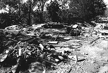
At the Hacking River Catchment Management Committee on Wednesday 24th June, a concerned member of the community brought along some photographs of a foreshore construction site. The photos (see accompanying photo below) showed earthmoving equipment pushing large amounts of rock and dirt down into the Port.
The location is close to the sensitive Shiprock Aquatic Reserve. The person who took the photograph reported the issue to Council and was told that this work was in accordance with the approvals given.
Surely given the extreme siltation of Yowie Bay, about which the authorities are prepared to wring their hands and beat their breasts, this type of practice should be of real concern to Sutherland Shire Council, Fisheries, or Dept of Land and Water Conservation. Is it really acceptable to these authorities to encourage landowners to push more mud and rock into the Hacking? Is it really best practice to allow the reclamation of foreshore areas, even down to below the water line (which we understood is beyond the boundaries of the property)? |
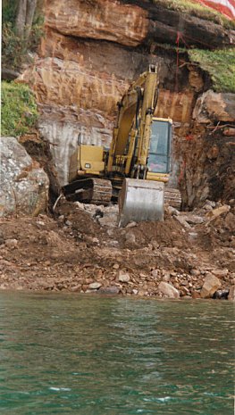 |
Current indications are that material damage has been done to sensitive seagrasses, and that it is most likely sediments have caused damage to Shiprock Aquatic Reserve. If the authorities are prepared to encourage this type of construction activity then it is they, not the landowner, who are responsible for that damage.
In the last Protectorate we raised the same issue in relation to Council works in Bundeena where they have accelerated the rate of sediment being transported into the bay through careless controls. This is another instance of the same lack of senstivity to the effects of treating the waterway as a convenient dump site. The authorities want the residents who have lost the amenity of Yowie Bay due to sediment resulting from past mismanagement, to pay to correct this problem. Surely the connection between sediment filling in heads of bays, and earth moving equipment pushing rock and dirt into the estuary, or large pipes pumping dirt into the Port, is sufficiently direct for everyone to realise that it is a major mistake that will come back to haunt us?
Stop Press
Small Project Fund 1997/98
The Hacking River Catchment Management Committee is in the process of disbursing a total of $33,992.50 to successful applicants for Small Project Funds. Successful Applicants are Sutherland Shire Council's Bushcare Groups at; Lilli Pilli Point Baths Reserve (bank stabilisation and revegetation); Lilli Pilli Point Reserve (Stage II - primary weeding), Coonong Creek (restoration of embankment), and Cabbage Tree Point (Stage II - primary weeding); Helensburgh & District Landcare Group (environmental projects and community education programs in the upper catchment); Port Hacking Protection Society (Inc)(land use history of catchment's south east quadrant); University of Western Sydney Macarthur (postal survey of local community for Koala and other wildlife sightings); and Southern Sydney Branch of National Parks Association of NSW Inc (Royal National Park and environs biodiversity survey (Stage 3).
Shell Road Both Ends
Shell Road traverses the Burraneer Point headland. The western end of Shell Road is occupied by The Burraneer Bay Sailing Club. The eastern end of Shell Road is a reserve covered by bushland. In the past twelve months, both ends have been subject to reports and debates in Sutherland Shire Council.
Burraneer Bay Sailing Club: Sutherland Shire Council has mediated a disagreement between the management of the Burraneer Bay Sailing Club and residents regarding the nature of the facility on the site. Sutherland Shire Council mediated on the basis that Council would:
-
expect the ultimate use of the Club to be no more intense than was occurring in 1993;
-
allow only junior waterbased activities;
-
not allow the storage of dinghies; and
-
only allow social activities related to Sailing Club activities.
Based on agreement by all parties (the immediate community, the administrator and occupant of the site), the Council adopted a permissible occupancy of the site based on it being a recreation facility only and not a registered club, recreation area and recreation facility, as originally proposed.
Shell Road Reserve: The Environmental Services section of Council recommended that the road reserve should be maintained in public ownership rather than sold for private development. In making its assessment, Council noted the site's physical attributes, capacity to provide public pedestrian access to the Gunnamatta Bay Foreshore and the Crown lands Assessment identification of its recreation, scenic and conservation values.
.....and on the matter of Road Reserves...
Council's Bushcare Forum highlighted the need to utilise zoning protection for bush reserves that have been created on Unmade Road Reserves, eg, Kareena Park Reserve. Caringbah Bushcare volunteers expressed concern that the Department of Lands or Council will use the unmade road reserves for other purposes. The Forum resolved to investigate into zonings and potential threats to bushcare sites on Crown land and on Council unmade road reserves so that strategies can be developed to ensure that these sites cannot be sold and will be retained as Bush Reserves.
....Not so lucky for one plot of land in Cronulla
A long-running battle by the North Cronulla Precinct Committee to save a parcel of land fronting Mitchell Road has been lost in the Land and Environment Court but is fighting its way to the Court of Appeal. The fallout from this battle of the land are a number of rather disturbing moves by Sutherland Shire Council: A motion to expedite sale of land by auction to pre-empt the appeal process; and determination to recover costs from residents. Neither move speaks well for Council's belief in the checks and balances that we, in this democratic country, have put in place to curb the power of authorities charged with community's welfare.
Community Forum on the Hacking
The Leader newspaper failed to distinguish itself by ignoring the Community Forum on the Hacking (see Contract article), and instead running a front page story in which a local marina owner attacked the Hacking River Catchment Management Committee (Leader June 30, 1998). Mr Harry Standen, proprietor of the Dolans Bay Marina, accused the HRCMC of being dominated by environmentalists bent on strangling the multi-million dollar boating industry, and of being comprised of people largely living outside the Shire. Mr Standen also claimed that boat owners lack a voice in important decisions made about the river. Mr Standen himself sits on the Port Hacking Planning and Advisory Committee, was a participant on the HRCMC organised study trip of the river on May 16 (see Sedimentation article), and attended the Community Forum, using the opportunity to ask several questions from the floor.
The Leader partially redeemed itself in its next edition (July 2, 1998) by reporting on the Forum, and printing a detailed rebuttal of Mr Standen's accusations by HRCMC chairman Peter Wells. He said that Mr Standen had never attended a meeting of the committee, written to the committee or applied for membership of the committee. Nominations for the Committee will open again in October. |
 |
Along the foreshore of Port Hacking, a major regulator of development is Sutherland Shire Council. The Council is taking many initiatives to mitigate unsavoury environmental effects of development. One of its most significant achievements was to adopt the Port Hacking Plan of Management in November 1992. The Plan potentially provides focus and priorities for dealing with many issues that affect the sustainable use of Port Hacking.
In charge of implementing the Port Hacking Plan of Management has been the Port Hacking Planning and Advisory Committee. It is difficult from reading the Minutes of the Port Hacking Planning and Advisory Committee to determine what it has achieved, (although many sections of Council and other organisations have been at work dealing with issues raised in the Plan of Management). One storm that has brewed from time to time is the issue of membership. In issue 10 of the Protectorate we noted that membership of the Committee was curious. It would appear now that the Chairman of the Committee is frustrated over the issue of membership, though it is unclear what triggers his frustration. To quote from the Minutes (Minutes of the Hacking River Catchment Management Committee Meeting of 25 June, 23 July, 27 August & 24 September 1997):
“The current community representatives on the Port Hacking Planning and Advisory Committee seem to be representing the views of more than one user group or organisation, and cannot express all views of those they represent. The Committee needs broad band representation and community representatives should not belong to specific organisations. He also stated that he has had representations from users of the Port Hacking expressing concern that they are not adequately represented or given the ability to help make decisions at the grass root level. The committee needs practical implementation of decisions which can be achieved through broad representation.” It would be interesting to know who on the Committee is not a "user" of the Port. It is also curious that there is a call that community representatives should not belong to specific organisations. Community interest groups are surely legitimate funnels of community concern. The members of community groups (who are users of the Port) provide legitimacy to representatives to represent them (it's what the word "represents" means).
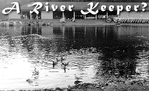
Membership aside, it is rumoured that the Committee might go through a "re-birth". A River Keeper is to be appointed who will be responsible for keeping the river clean in the future but also for cleaning off its past pollutants, and educating people along its banks of its importance (Leader, Unlimited 1998). The River Keeper will be able to do this with an establishment cost of $150,000 and annual on-going costs of about $60,000. River Keeper programs have worked very well in the US. Hopefully, the program in Port Hacking will be successful.
And the Port Hacking Planning and Advisory Committee? It is the government appointed Estuary Management Committee. It is the channel for obtaining Department of Land and Water Conservation grants for estuary management. Presumably, if it is reconstituted it will not cut off this important source of funding to help the community achieve a sustainable, environmentally healthy future for Port Hacking. Hopefully, too, the enthusiasm for the River Keeper program is not moving Sutherland Shire Council away rather than towards an integrated approach to Managing the Port Hacking catchment. Sediment and Pollution in the Port
On a rain-filled morning on the 16th of May 1998, a group of individuals joined a half-day river cruise of the Hacking waterway to learn about the geography of the waterway: its geological history, its biological makeup, and its human activity. Present on the cruise were boat owners, marina operators, environmentalists, representatives of Sutherland Shire Council, scientists with an intimate knowledge of Port Hacking, as well as members of the cruise's organiser, the Hacking River Catchment Management Committee. |
|
The scientists and participants provided a range of detail and insights into the issues confronting the management of Port Hacking. Not the least of these is the perennial issue of dredging; how, where, why, what, when....
We've reproduced for you on these pages, some of the information revealed on that cruise - information vital to any discussion of how we sustainably manage this beautiful area.
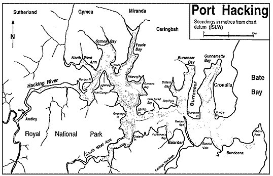
Port Hacking 2,000,000 years ago to present |
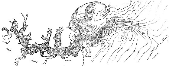 |
Port Hacking is a drowned river valley. Over the past 2,000,000 years, the sea level has risen and fallen several times. Each time the sea level was low, the Hacking River cut into rock, gouging a deep valley. The deepest part of the Hacking River valley is 95 meters below current sea level off Port Hacking Point (Jibbon Point). During these low sea-level times, the Hacking River carried the sediment its scouring activities produced, as well as other land-based erosion out to see, depositing it about six to eight kilometres from the present shores.
Each time the sea level rose, the portion of the valley closest to the seas was drowned by marine water. The waters, through action of waves and tidal currents transported sediment back into the Port. When the sea level fell again, part of the loose sediment was again pushed back out to sea.
About 18,000 years ago, the sea level rose again, stopping at its present level about 6,000 years ago. Sediment partially filled the valley as it had previously. The George's River, running almost parrallel the Hacking River, was subjected to the same forces of erosion and sedimentation. The Kurnell Peninsula, located at the confluence of the streams, is the most dramatic example of the return of sand from the seas.
Movement of the current marine delta |
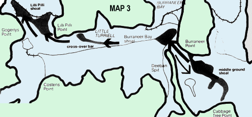 |
Most of the area between the entrance to Port Hacking and Lilli Pilli Point is occupied by a "marine delta". This delta is mostly sand that has been pushed back into Port Hacking over the 12,000 years that the sea level slowly rose. It is composed of 160 million tonnes of fine grained sand. There is very little new sand entering Port Hacking from the sea, but the marine delta continues to move slowly inland at the rate of 13,500 cubic metres per year, moving into Gunnamatta Bay, Burraneer Bay, South West Arm and up into the Hacking River. By the 1920s, the middle ground shoal, off Cabbage Tree Point, was dividing. One division moved west towards Deeban Spit. The other division shoaled Simpsons Bay and infilled Cabbage Tree Basin. From 1965 to the present, Deeban Spit formed its new shape and sand continues to move west.
Movement of the current riverine delta |
 |
Even though sea levels have drowned the mouth of the Hacking River, the upper reaches of the River continue to carry sediment load downstream. Most of the sediment is find sand, silt and mud with some vegetation debris. It is deposited along the course of the river in pools and as sand banks. During small floods, this material is transported further downstream and deposited upstream of the causeway at Audley. During larger floods, sediment is lifted over teh weir and most of it settles out 2 to 5 kilometres below the weir as a "riverine delta". This delta extends from Audley to Grays Point, growing at the rate of about one metre every 12 years (or 10,000 cubic metres per year).
Man's impact on sedimentation
Movement of sand in the Port has not only been effected by natural elements. Man's activities has had a deal of input. The marine delta, the riverine delta and the heads of bay have all felt the impact of man's activities.
In 1901-1902, nearly a third of million tonnes of sand was dredged from Simpsons Bay to create access to a fish hatchery in Cabbage Tree Basin. This dredged sand was dumped on the middle ground shoal off Cabbage Tree Basin and Deeban Spit. In the 1930s and 40s the "spoils" from shellgrit Mining caused many more tons of sand to be dumped into the waterway around Deeban Spit. Since the mid 1970's there have been nine rounds of dreding in the Port. Most of the dredging has taken place within the entrance to Gunnamatta Bay and in the channel off Burraneer Point. Each time 60,000 to 90,000 cubic metres of sand has been dredged. Each time dredging takes place and sand is moved to another place in the Port, the natural elements work to find another equilibrium. Ultimately, that is the inexorable shift of sand into the higher reaches of Port Hacking.
The riverine delta has also felt the effects of man. The Audley Weir is a most dramatic influence on the upper reaches of the delta. But this delta was the site of the first round of dredging in 1881 to keep open the ferry route to Audley.
Meanwhile, many northern tributaries of the Hacking River, although now confined in drains, carry sand, mud and debris which are deposited at the heads of bays.
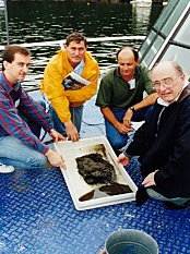
PHPS Annual General Meeting
The Port Hacking Protection Society (Inc.) held its Annual General meeting on Sunday, 8 March 1998. The outgoing President, Paul Martin, gave his report noting achievements of PHPS in 1997 and restating the objectives of the Society. This is reproduced in the accompanying box.
As required by the Constitution, all members of the Committee stood down and a new Committee was elected. The new PHPS Committee comprises: John Atkins (Chair), George Harrison (Secretary), Victor Leuliette (Treasurer), Phil Parsonage, Richard Rogers, Paul Martin and Miriam Verbeek. |
Strategic Concerns |
Particular Issues |
Our Objectives |
| Usage of Port Hacking should be on a sustainable basis |
-
Seagrasses
-
Foreshore biodiversity
-
The impact of sediments
-
Pollutants
-
Foreshore vegetation
|
-
Highest possible degree of protection for the Posidonia beds within the Port, as these are not amenable to regrowth ie Jibbon
-
Balanced protection of the other important areas, particularly against vessel impact ie Simpsons Bay. The Basin.
-
Control of the over-harvesting of the foreshore marine life
-
Effective control of polluntants and sediment at source ie Yowie Bay, Bundeena sewerage
-
An effective foreshore code, to protect the aesthetics of the Port, and to preserve (as far as possible) natural vegetation and filter strips
-
Effective management of small, high powered vessels (noise and safety threats) in proximity to residents, swimmers etc, ie PWCs
|
| The management of the Port should be on a basis that protects the rights of all user groups, notably the low impact users such as swimmers, surfers, canoeists etc, and foreshore residents and users. |
|
-
Effective management of small, high powered vessels (noise and safety threats) in proximity to residents, swimmers etc, ie PWCs
-
Creation of areas where low key use is fully protected in Horderns, Simpsons Bay
-
Control of boat and foreshore based sewerage contamination ie Bundeena, through-hull and Jibbon
-
Proper facilities for management of trash, boat mooring, sewerage etc in high-usage areas ie boat ramp
|
| A management framework that provides an effective safeguard against incremental destruction |
-
Clear identification of the areas under threat and the nature of the threat.
-
A planning framework that deals with the issues in an integrated manner.
-
Reduction of jurisdictional barriers to integrated management
-
Effective enforcement
|
-
The creation of a single integrated framework and an authority with the power to manage Port Hacking on that basis ie lobbying
-
Consensus based decisions within the community to protect the environmental and recreational values of the Port ie draft plans
-
Effective monitoring and reporting on policing, enforcement and environment, ie Waterways, submissions
|
|
Changes to Residential Controls in Sutherland Shire
Sutherland Shire Council has prepared the draft Sutherland Shire Local Environmental Plan 1993, amendment No 57, which is currently on exhibition in the Shire.
The Council's stated aims of this plan are to simplify residential controls, remove some of the inconsistencies in the current plan and to help achieve the the objectives of the Sutherland Shire Housing Strategy.
Two aspects that we need to consider when assessing this plan are the effects on the urban environment and the implications for the Port Hacking.
There are two changes proposed that have the pontential to increase urban runoff and add to the siltation and pollution problems.
Minimum Lot Size
The proposal here is to allow 3 dwellings on areas of 900sqm to 1200sqm. Under the current plan a maximum of 2 dwellings can be built on lots of this size, ie. a dual occupancy. If the block next door to you is 900sqm, a little smaller than the old quarter acre block, and assuming other conditions have been complied with, it will be possible to build 3 dwellings on it where now there is one.
The effect of this, apart from the loss of privacy and permitting the infilling of many small areas of the Shire, would be to further decrease the area of pervious soil. This, of course,will add to one of the greatest threats to the integrity of the Port, urban runoff. It seems the intent is to extract the maximum development potential from every lot in the Shire. |
 |
Landscaped area
The effect of this change would be to reduce the amount of landscaped area required in future developments by 5% in all residential zones. A benefit of this would be to make villas more viable by reducing the actual landscaped area, but now requiring that it not be fragmented and be able to support more useful trees and shrubs. However, overall the proposal is too sweeping and should be restricted to specific developments only. There are new objectives for landscaped areas in the plan, and they are excellent. Even more so if applied to the existing landscaping codes.
Loss of soft landscaped areas will inevitably result in more runoff and more pressure on our waterways.
The draft plan is on exhibition at the Council Chambers, Sutherland, and at all libraries, until July 31. Take the time to read the document and send your submission.
"Community Contract" for Healthy Hacking
Over 100 people gathered on a perfect winters morning at the Fisheries Research Institute in Cronulla recently, to share information on the Hacking and to develop a "Community Contract" to achieve a more integrated approach to the catchment. This was the first Community Forum, an initiative of the Hacking River Catchment Management Committee(HRCMC). Representatives of government departments, local councils and community groups gave short presentations and answered questions relating to their particular roles.
Chairman of the HRCMC Peter Wells thanked the Director of the Institute, Rick Fletcher, for the use of the conference facilities, pointing out to the audience that many of the buildings on the site had received heritage listing. Dr Bob Smith, Director General of The Department of Land and Water Conservation (DLWC), then launched the forum. He noted that DLWC was committed to the development of catchment management committees, and pointed out that expenditure on the Hacking had increased 200% since the establishment of the HRCMC in 1993. He called on all participants in the Forum to sign the Community Contract, which committed the signatories to perform concrete tasks and actions.
Regional Director of DLWC Axel Tennie emphasised the quantity of research and publication his department was involved in. He displayed publications which profiled the Hacking catchment, its soil analysis, sedimentation and erosion, and emphasised the imoprtance of this type of information to planners and engineers. DLWC will have this information on the Internet soon to enhance its accessibility.
Tim Tapsell, Project Manager of the Sutherland Shire Environment Centre detailed SSEC's role in the battle against increased development around Helensburgh in the Upper catchment, the fight against offshore mining and support for a Marine National Park offshore from the Royal. Mayor Kevin Schreiber from Sutherland Shire Council detailed SSC support for the catchment management process, commitments on efforts to prevent entry of rubbish in waterways , including trash racks and improved codes in building practice.
President of the Port Hacking Protection Society (PHPS (inc) John Atkins gave a brief history of the organisation, and emphasised the organisation's educational role through the production and distribution of the Protectorate. PHPS(inc) members also participate in the HRCMC, and the Port Hacking Planning and Advisory Committee. John noted that PHPS(inc) had been instrumental in the development of the Memorandum of Understanding on Navigation, which provided a context within which dredging of navigation channels could take place and had worked to develop a strategy for protection of seagrass beds and other sensitive areas of the Port.
John Webster from Sydney Water updated the meeting on the upgrade of the Cronulla Sewerage Treatment Plant, and the latest on the plans for the sewering of Bundeena-Maianbar. Allan House, President of the Helensburgh and District Landcare group, detailed the work of his very active group in weed eradication, bush regeneration and rubbish removal in the upper catchment. Peter Stevens, District Manager of the National Parks and Wildlife Service, emphasised the philosophy NPWS was trying to develop, but also appealed for the community's help in removing the problem of Rusa Deer in the Royal. NSW fisheries Conservation Officer Jack Hannon gave a detailed overview of fish types and habitats in the Hacking, and voiced Fisherie's concerns and actions in dealing with the threats faced.
Dick Rogers, Bushcare Officer with Sutherland Shire Bushcare group, detailed weed eradication programs, and native bush regeneration from seed programs in forshore areas of the Port. He also noted the problems encountered with individuals removing tree cover to "improve" views.
The Forum was also addressed by Councillor Kerrie Christian, from Wollongong City Council, Joe Woodward, Sydney Region Director of the Environment Protection Authority and John Hickey, Environment Officer with the Waterways Authority.
Peter Wells said he hoped that the Community Contract would help to develop a more integrated approach to land and water management, and would be a commitment on the part of all signatories. He hoped the Community Forum would become an annual event.
Ruminations
Who Cares? The River is not my Problem
A. D. Oosthuizen - June 15, 1998 |
"These are the days by the sparkling river
His timely grace and our treasured find
This is the love of the one magician
Turned the water into wine" |
|
These lines from a song by Van Morrison sum up my gratitude for being fortunate to live on the shore of Port Hacking.
Fourteen years ago, I accidentally visited Bundeena, could not believe a place as pristine as Port Hacking could exist on the edge of an international metropolis, fell in love with it, and have lived here ever since. As a designer of waterfront homes, I work, live and relax on the edge of the water. I find that, if you let it, the river replenishes the body and soothes the soul like good wine.
Here in Port Hacking we can still see the rays and mud crabs on the clear bottom, see the remaining pair of sea eagles swoop to snatch fish out of the water, be surprised by the occasional pod of dolphins or penguins investigating the river, snack on a rock oyster, and swim without getting sick. Port Hacking is now the only waterway in Sydney still relatively safe to physically interact with.
I am impressed by how most foreshore residents take care of and look after their private properties and prevent pollution from their land entering the river. Unfortunately, the same cannot be said of our public and commercial infrastructure. From these, the bulk of the Port Hacking pollution comes from. To date, only a fraction of our storm water system is fitted with siltation traps and garbage filters. Sewer overflows drain into the waterways. Council road works and large commercial developments contain little run-off control measures.
The incremental damage this causes is blatantly obvious at low tide after rain when the north shore tidal inlets which receive runoff from streets and commercial developments makes one wonder whether Sutherland rubbish tip has migrated into the river on oily silt. Where a decade ago there were white sand inlets full of nippers, soldier crabs and the like, now there is smelly oozing mud you sink into. Similarly, where long time residents can remember clear sand and sea grasses on the bottoms of deeper sections there is now a cover of silt and rubbish. Tidal flows are too limited in the bays to flush the sediment, and it keeps on building up, incrementally killing off the bays. |
 |
Somehow we tend to ignore this incremental damage to our river, as if it is not our fault or business, and we allow it to continue. We tend to physically cocoon ourselves from the river in houses with plate glass windows like TV screens, artificial air conditioning, ventilation and heating. We install private 'rivers' in the shape of heated swimming pools and spas. Cabin cruisers, jet skis and yachts have replaced the board shorts, surf skis, dingies and surfboards of our youth.
Our terms dictate. As we physically separate ourselves from it, the river becomes abstract, as if displayed on an IMAX screen in Darling Harbour.
This cultured physical apartheid results in us becoming insensitive to the needs of the river, as our accepted usage right prevails. We see it, but don't feel it. The river is a million dollar view, not something alive, needing protection from the damage our recreational and commercial activities cause. We spend money and time on our water entertainment, but put no equivalent effort and little money into maintaining the health of the river that provides the entertainment in the first place. We see no need to accommodate the health of the river, we float above it in artificial comfort.
After all, it is not as if we are dependent financially on its health. As long as property prices keep rising and there is a channel deep enough for the boat, who cares? So we attempt to shape the river to our entertainment needs, rather than modify our behaviour and expectations to respect its needs. The river becomes a dredging problem. A cost to keep the sand bars open for our boats. Because we now see it as a problem, we do not notice it is actually an asset. So we no longer notice what collectively we are doing to it, that way we avoid recognizing responsibility and guilt.
We assume the right to enjoy the river, while having somehow delegated the responsibility for looking after it to someone else. If we indeed have this right from our descendants, what is the obligation that follows? Do we really own our waterfronts, and therefore the river, to do with what, and as we like? How can we if in a few short decades we will all be dead and gone? Personal ownership is finite at best. Or are we as mortals fortunate custodians of our children's natural heritage?
In this information age, we must remember our children are often more informed than we are. They are aware of the care we show, or damage we do to the environment they must live with in future. Do we want to teach them it is alright to create wealth by destroying something else? Is wealth and heritage measured in dollars only. Because the river has not been attributed a monetary value, does it mean it is dispensable? Have clean water, sea eagles, mud crabs, dolphins and fish no value, simply because we do not account a profit to them?
It is within our power and discretion to care for our sparkling river. We are the fortunate few in the world to live in a place like this. We are the fortunate few, who due to our positions in the socio-economic scale can most afford to care, can most effectively influence the course of events. We have a choice. It is our choice if the sins of our wealth visit the children and the children's children.
Do we care enough to let these days by the sparkling river continue for our children? or shall we spoil the wine for them?
Dear Editor - By Phone
One caller rang to to ask why he received the Protectorate and added: "I don't agree with everything you print in the newsletter, but generally it's pretty good".
We told him that everyone on the foreshore and upper catchment of Port Hacking receives a Protectorate. We distribute 10,000 copies per issue. If you want to be sure you receive a copy, join the organisation (for $5 a year) and receive one in your mail.
Dear Editor - By Letter
The Dreaded Tombolo
Dear Editor,
A couple of trifling setbacks to our pleasant town (Bundeena) would follow the building of a sandspit/Tombolo (resurrected by Councillor Andrew Hodson and Bernie Clarke in the Leader. May 21, 1998), extending north from cabbage Tree Point Bundeena:
-
the lower half of Bundeena would sail away into the Pacific Ocean
-
Bonnie Vale would cease to exist as a clean safe beach
Both these truths should be pretty obvious, but at the risk of pedantry I expound as follows:
-
An artificial sandspit would not survive the two metre swell which comes in from the northeast during storms. Therefore the seaward side of the spit would need to be armoured by a rock wall. Wave energy would then be reflected straight on to Hordern's beach destroying it, breaching the dune line and inundating lower Bundeena.
-
Bonnie Vale would become a polluted, stagnant backwater, only fit for a boat harbour or marina.
The emotive howl of large boat owners is: "The Port is being choked by sand, a Tombolo would solve all our woes!"
The fantasy of invading sand was well and truly scuttled by a document from the Department of Mineral Resources which stated that sand had not come into the Port for 8,000 years and the if dredging was stopped today, the Port would remain in much the same shallow state as it has done since that time, and into the foreseeable future!
The Sutherland Council should be ashamed that they espouse this engineering nightmare by depicting in on some of their tourist maps of Port hacking.
But given Council's duplicitous treatment of anti-tombolo submissions preceding the aborted original tombolo enquiry, back in the days of Wal Murray (Minister for Public Works), perhaps one should not be surprised.
I Hodges - Bundeena
Jetskis too close!
Dear Editor,
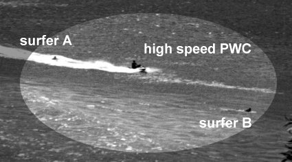
About a month ago I was taking some photos of the Port, to send to some friends O.S. I wanted some of the surfers off Cabbage Tree. Waiting till a day when the conditions were right I took my trusty SLR down to the water.
After a while, when I got some nice shots, a couple of jetski riders came roaring across the bay. Not content with the noise he created, one of these riders decided to get among the board riders. The photo I took (attached) shows this @#$ßG@^Q@ person travelling at high speeds along the crest of a small wave (the PWC is roughly moving North West to South East). He has just cut in front of one board rider (missing him by about a foot or so) and is moving directly towards the second (whom he barely missed).
There was no way he could properly control his machine, as the waves were coming in sets of small and large and there was no way he could predict when the next large set would be upon him. The boardriders were put in real and unneccesary danger.
If the riders of these machines were responsible they would go to other places where they don't expose others to risk. Using these machines close to swimmers or boardriders is the height of stupidity.
Name and address withheld on request |
 |
| top of page |
|