History |
Towra Point has not always been a Nature Reserve |
Recent History |
Date |
Event |
| 1999 |
New Draft Plan of Management was released for public comment |
| 1997-98 |
A review of the Plan of Management was undertaken |
| 1997 |
Friends of Towra Point Nature Reserve established |
| 1996 |
Volunteer bush regeneration program started |
| 1992 |
Conservation zones in the Aquatic Reserve were modified
Little Tern management program started |
| 1989 |
A Plan of Management was adopted for the Reserve
Sydney Regional Environmental Plan No.17 - Kurnell Peninsula adopted |
| 1987 |
The Towra Point Aquatic Reserve was declared |
| 1984 |
Towra Point was listed as a Ramsar site |
| 1982 |
Towra Point was declared a Nature Reserve |
| 1975 |
282 ha of land acquired by Commonwealth to satisfy the JAMBA agreement |
|
Aboriginal
Aboriginal use of Towra Point is evidenced by middens containing the remains of shells and tools. There are four known aboriginal sites at Towra Point. (3 middens and 1 relic) The area was rich in seafood and the ponds provided drinking water for many groups of Aboriginals. |
|
|
Captain Cook
In April 1770 British explorer Captain James Cook explored and mapped the whole of Botany Bay including Towra Point. The map he produced is pictured below. Neither Cook, nor Botanist Sir Joseph Banks made any specific mention of Towra. It is also evident that Cook mapped Towra lagoon during his visit and as a result, this lagoon has become one of the Reserve’s most significant historical assets. |
 |
First European Colonisers
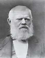
Cattle and horses were run on Towra Point by early settlers but there was little development of the land. After Thomas Holt (below) purchased the estate in 1861, the peninsula was divided into paddocks, some cultivated and others used for cattle and sheep grazing. Seventy acres on the western side of Towra Point were cleared, ploughed and sown with corn. Sheep were not particularly successful and thousands of them affected by footrot were destroyed and buried at Towra Point. Holt also commenced the first plantings in Australia of Buffalo Grass (Stenotaphrum secundatum), which is now a significant weed within the Reserve. |
 |
|
Oyster farming
Holt pioneered oyster farming in the late 1870s by installing oyster structures in and around Weeney Bay at Towra Point. The sites of these early oyster farms are also potentially valuable as cultural heritage. Today oyster leases are still utilised at Towra, located in Quibray Bay
Radar Station
The elevated causeway through the entrance of the Reserve was built between the years 1947 and 1951. The road led out to a radar station which was operated by the Department of Civil Aviation. The tower is no longer there but there is an old vehicle as well as a shed, both of which you can view on our Virtual Tour.
Geomorphology of Towra
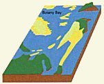
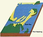
Towra Peninsula arose due to coastal processes that accreted alluvial sand and formed a series of large sand bars, believed to be about 4,000 – 7,000 years ago. The sand bars coalesced and formed the existing peninsula. Geologically, Towra Point consists of deep, unconsolidated alluvial sands. Nutrient rich organic muds and muddy sands have deposited in low energy depositional environments, such as Quibray, Weeney and Towra (Stinkpot) Bays. The Formation of Botany Bay
Ancient estuaries all around the coast were ‘drowned’ when the sea returned to its present level after the last ice age. It was a gradual process, with marine sand being pushed up to form beaches and sand bars in places where there was a large enough supply of sand; these were then driven ashore to form beach ridges and dunes, and infilled estuaries. Here is a geologist’s reconstruction of what is believed to have happened in Botany Bay: |
|
| top of page |